jacobsjo's Tools and Projects

Welcome to my collection all the Minecraft tools I've worked on, as well as other and minor projects. Display and edit biome layouts, debug structure generation, and design terrain unsing density functions! Feel free to also check out the source code on GitHub.

If you find my tools usefull, I would apreciate if you consider to Sponsor me on GitHub.

Maybe you are looking for my personal blog instead?

Also check out the Minecraft Wiki!
I've contributed to the documentation of custom world generation there. Check it out!

Minecraft Tools

NOT AN OFFICIAL MINECRAFT SERVICE. NOT APPROVED BY OR ASSOCIATED WITH MOJANG OR MICROSOFT
map logo Datapack map
A map showing biomes as different colors and markers for structures. Some shading is done to show terrain.
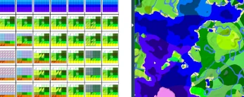
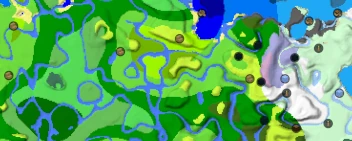
A map to display biome layout, terrain, and structure locations of minecraft worlds. Made deliberately to support custom worldgen datapacks, such as Terralith.
Help Translate Datapack Compatability (Wiki) View Source on GitHub
snowcapped logo Snowcapped
A section of the snowcapped editor. Split into two parts. On the left a grid is seen where each cell contains another grid filled with colors. The right shows a map where the colors represent different biomes.
An editor for compley multi-noise biome configuations. Based on the vanilla overworld configuation setup, this editor allows the easy creation of 6 dimensional configuations.
Legacy 1.18 version Documentation (Wiki) View Source on GitHub
A jigsaw block as a logo. Jigsaw previewer
Parts of a plains village during generation on hilly terrain. The jigsaw blocks are still visible. A street is marked with a green outline. Other houses connecting to the street are shown with red and blue outlines.
A previewer of structure generation from jigsaw configuations. Allows for debugging of generation issues, such as bounding box intersections.
View Source on GitHub
Density function editor
Parts of a visual flow diagram. The test is unreadable, so that only the general structure is visible: Multiple nodes that are connected with edges. On one of the edges a tooltip is open showng an image that is mostly white and red but contains a few black spots, indicating caves.
A visual flow based editor for density functions. Density functions can be created by connecting individual nodes using edges. Includes 2d visualizations of the density functions.
View Source on GitHub
Worldgen Devtools mod
A Minecraft trial chamber with a number of jigsaw blocks present. The jigsaw blocks have different colors.
A mod that aids in the development of world generation data packs and mods. Allows reloading worldgen data packs in-game and resetting chunks. Colors jigsaw blocks by name and target.
View Source on GitHub

Minor Minecraft Projects

NOT AN OFFICIAL MINECRAFT SERVICE. NOT APPROVED BY OR ASSOCIATED WITH MOJANG OR MICROSOFT
MC-Icons
Repository containing images of all minecraft icons. Auto-created from vanilla resources.
Saddle Valley Rivers
A datapack that adds underground rivers and canyons to saddle valleys.

Other

Windy sun position plugin
This image consists of two parts. On the left there is a part of a timeline, going top to bottom showing times of the sunrise, blue and golden hour and nautical twilight. On the right there is a map showing the surrounding of Insbruck with a marker with multiple dashed lines going in different directions.
A plugin for windy.com that shows directions of the sun and moon. It also giv sunrise, sunset, golden-hour and other timings.
Forum Post View Source on GitHub